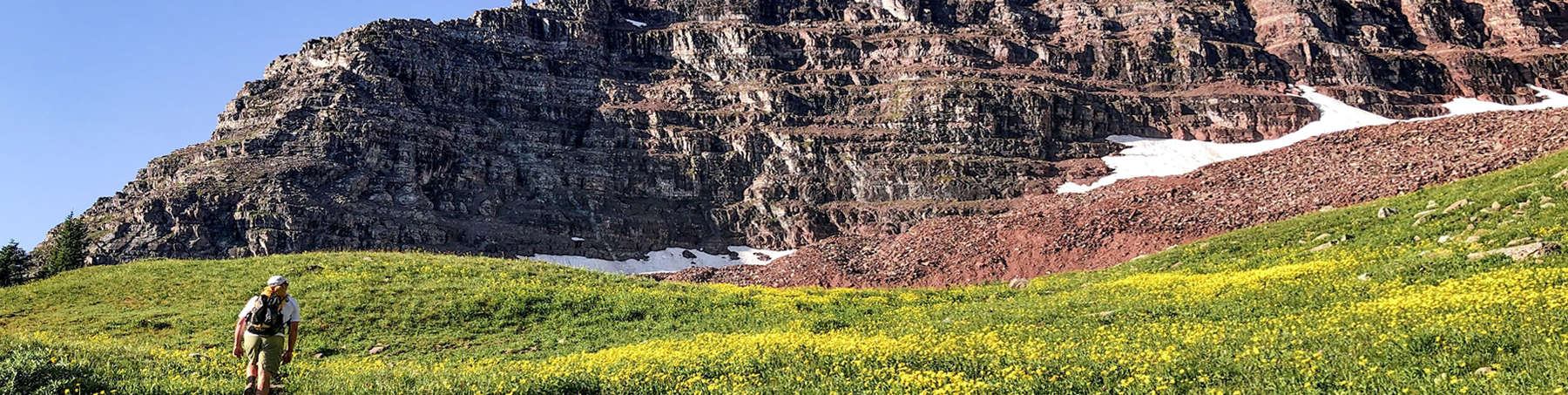
The surrounding Aspen area, from Maroon Bells to Independence Pass, offers many recreation opportunities and trails for summer hiking, mountain and road biking. Here are 10 suggestions. Some trails begin right in Aspen while others require a short drive to the trail head. When your in town, pick up the free Ute Scout: Mountain Hiking and Biking Guide for an easy-to-use information map of the area.

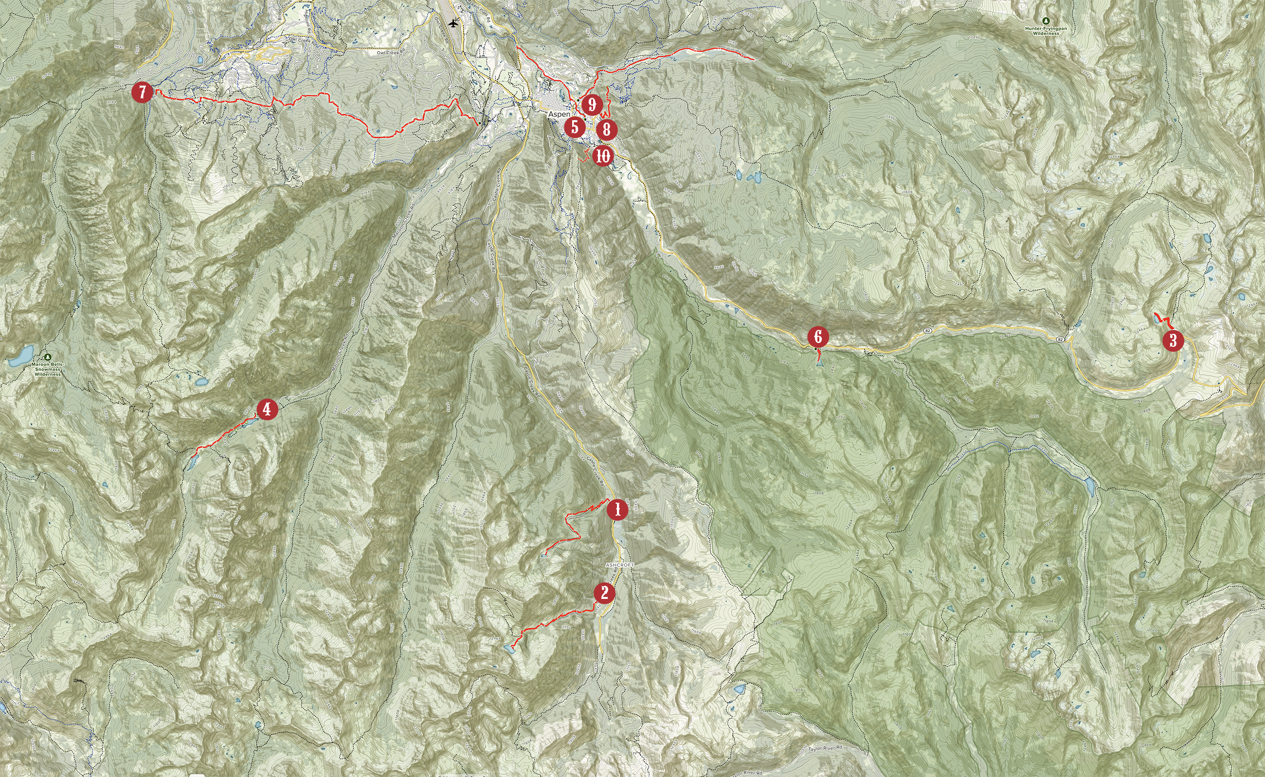
Rio Grande Trail
In entirety, this old rail road grade is a 42 mile stretch from Aspen to Glenwood Springs. The trailhead is just below Clark’s Market off Puppy Smith Road across from the Post Office and is very accessible and very popular. It's ideal for any family outing as it is an easy, ever so slight, down hill 2 mile sidewalk running along the Roaring Fork to Cemetery Lane with small parks and rest areas and bridges along the way. Across the river, a nice footpath runs between the bridges, up to the Music Tent or up Castle Creek. Runners, bikers, walkers among other enthusiasts can all find their escape.
Cathedral Lake Trail
Another uphill climb ascending 2078 feet through the Pine Creek Canyon. The scenic views of the Elk Mountain Range are spectacular as you climb through aspen forest, meadows, and scree fields to the Lake. The rocky Cathedral Peaks tower above the lake, enchanting your well earned accomplishment. The ambitious can break the spell and continue up to Electric Peak for remarkable 360 degree views. From the roundabout, take Castle Creek Road and drive 12.2 miles, turn right (shortly after passing Ashcroft) onto a rough rocky road, driving 1/2 mile to the trailhead.
American Lake Trail
A classic uphill climb to a beautiful high mountain lake. Gaining 2020 feet in elevation is, nevertheless, rewarding as you pass through groves of aspen trees and pine forests, occasionally opening up to meadows or views of the surrounding peaks. The forests are rich with sounds and aroma of wilderness - gorgeous in the fall and spring. From the roundabout, take Castle Creek Road and drive 10 miles to the Elk Mountain Lodge. Turn right into the American Lake parking lot for the trailhead.
Linkins Lake Trail
The trail head serves both Lost Man Trail and Linkins Lake Trail. You will be starting this hike at 11,507 feet and quickly gain another 528 feet in elevation to a glacial cirque with an alpine lake, tundra and truly magnificent views of the Continental Divide. At this altitude, snow can last well into the spring and summer but the wildflowers will encourage you to press on. Drive 13 miles east of Aspen on the last switchback before the top of Independence Pass.
Crater Lake Trail
Crater Lake, a small alpine lake that sits at the base of the Maroon Bells. The trail is a heavily trafficked rocky trail with a moderate grade, about 550 vertical feet in gain over a mile and a half, through aspen groves, scree fields and old avalanche terrain. From the lake, are great views of the Maroon Bells, and Aspen’s famed 14,000-foot peak, Pyramid Peak, to the left. West Maroon Pass, the popular hiking route to Crested Butte, is accessed via the south and east sides of the Bells.
Weller Lake Trail
Just over a half mile each way, this is an easy walk into the Collegiate Peaks Wilderness. The trail has some slight ups and downs, gaining only 200 feet or so in elevation as it meanders through the forest to the lake. The scenery is wonderful, though the fishing is just fair. All in all, this is a lovely walk and a great option to stretch your legs if you're coming in from the pass. Access from HWY 82, approximately 7.5 miles east of town.
Government Trail
Government Trail is closed for elk calving from mid May thru mid June. Running almost 10 miles, it's a moderate trail and an enjoyable day hike or mountain bike ride. There are some ascents and switchbacks as the trail alternates through aspen groves, ski runs and lodgepole pines. This is a hike where a car shuttle is helpful. It is also known as Brush Creek Trail and is a popular cross country ski trail in the winter.
Smuggler Mountain Trail
The lower end of Smuggler Road is used heavily by walkers, hikers, bikers and runners. This popular road provides a short, steep, 1.5 mile workout leading to historic mines, large groves of aspen, and a platform with incredible views of the Roaring Fork Valley and Aspen town. This road/trail continues on another 5.5 miles up to lake. East on Main Street, turn left (north) onto Mill Street. Travel 1/4 mile and turn right after the bridge onto Gibson. Follow Gibson 1/8 mile to a Y intersection and bear left onto South Avenue. Shortly, turn right onto Park Circle and follow for 1/8 mile to the Smuggler Mountain Road on the left.
Hunter Creek Trail
This is a moderate hike with good views of the Elk Mountain Range and the town of Aspen. The trail head from the Rio Grande Trail is shaded and runs along the creek. The first mile up to Benedict Park and jut out to the switchback for great views of town, then come back to the trail and continue on. The trail is heavily used by mountain bikers, hikers, joggers and their dogs. These trails provide great access to other trails and backpacking options into the Hunter Valley.
Ute Trail
This shady trail of switchbacks ascends steeply (over a thousand feet in under a mile) to a rock outcropping at 9,185 feet. The view of Aspen that rewards you is spectacular. If the first mile isn't enough, continue up the ridge two more miles on the Ajax Trail which then skirts the ski lift and then delivers you to the top of the mountain to enjoy breathtaking panoramic views, summer entertainment while enjoying some food and spirits at the Sundeck. Once relaxed, ride the free gondola down. Save your knees the downhill trek.